Jerusalem through the Ages
I am now starting to draw a new section of the comic. I have completed the Samson story and considered which bit to cover next. I have some good ideas for the Ehud section, but as Ehud story comes in just five pages in from the beginning, I decided to start at the beginning of the book. I know, madness.
As I go along illustrating the comic I have to refine my broader research into specifics. One of the first things to research was the city of Jerusalem, as it shows up in Judges 1:7.
As Jerusalem features in the Bible from Genesis to Revelation and a time period of over four thousand years I had already decided to draw the Holy City from the same angle whenever it appears in the story, so as you read through the books of the comic you will see it growing and developing over time.
I've heard some preachers say one element of the Bible is “A Tale of Two Cities”, concerning Jerusalem and Babylon, as almost characters in this millennia spanning narrative.
In (very) brief, Jerusalem appears in Genesis 14:8 under the name Salem, later in the Conquest period it is called Jebus and is inhabited by the Jebusites (Judges 19:10) It is captured by David and renamed Jerusalem and goes on to grow under David and Solomon and other later Kings. It is destroyed by Nebuchadnezzar II in around 587BC (Jeremiah 52:6) and the walls are later rebuilt by Nehemiah. The city continues to grow and change hands through to Jesus' time and is then struck again in 70AD when the Temple is destroyed. The city then continues to grow until the modern day again changing ownership several times. The city features heavily in the book of Revelation also which will be in the End times. (Revelation 11)
In Judges, Jerusalem is a town called Jebus. In order to draw it as it would have looked I first needed to find out what the topography of Jerusalem’s steep hills and deep valleys. I was very happy to discover this is something that has been extensively research and even modelled before. This relief model below shows the hills as they are without any building on and just a faint line marking out the where the city walls stand today.
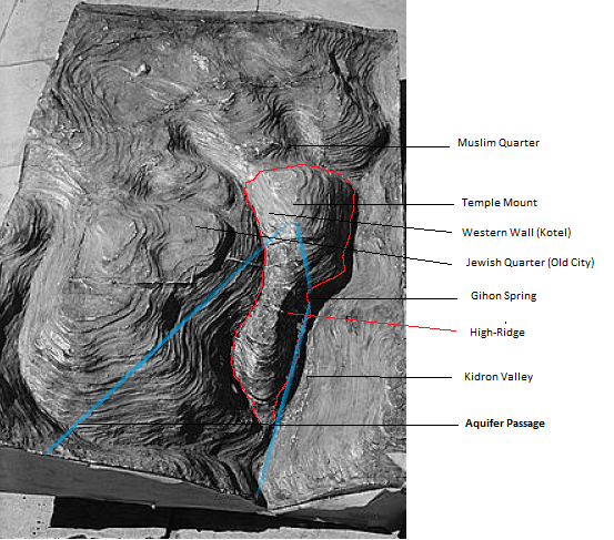
This amazing site even has a fly over video of how the city would have been in Solomon's day. (20 secs in)...
I found a map with the location of Jebus
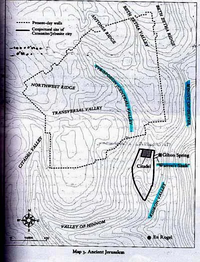
...and was able to overlay it with the topographical relief (this image shows the map and maps of later ages overlaid with the topology. The red dot is the location of where the temple would be built)...

I found an entry on Wikipedia about the Walls of Jerusalem and thus discovered that Jebus would have had wall in the Late Bronze Age (http://en.wikipedia.org/wiki/Walls_of_Jerusalem) and so from this I was able to draw the hills and accurately plot the location of walled Jebus.
My image views Jerusalem from the east, just over from the Mount of Olives. You can see I've used the blue guides to line up the ridges and referred to other photos of the area to get the heights correct.

Jebus
Now all I have to do is set it on fire and it's all done! (Judges 1:8b).
I think it will be very interesting to see the urban sprawl of this great city through to millenia, and it's a great privalige to be able to use this under valued and often misunderstood medium to visually present the historically development of, arguably, the most significant city on the planet.
